Author: Patrick Edwards
Each decade, the U.S. Census Bureau counts all persons living in the country and allocates congressional representation to each state according to its population. Called apportionment, this process results in some states gaining and others losing seats in the U.S. House of Representatives and, consequently, votes in the Electoral College. States adjust for these population changes by redrawing their electoral maps in an activity dubbed redistricting. States respond to apportionment and undertake redistricting in various ways. Most states give legislatures control of the redistricting process at the congressional and state legislative levels, though others give redistricting power to political or independent commissions.
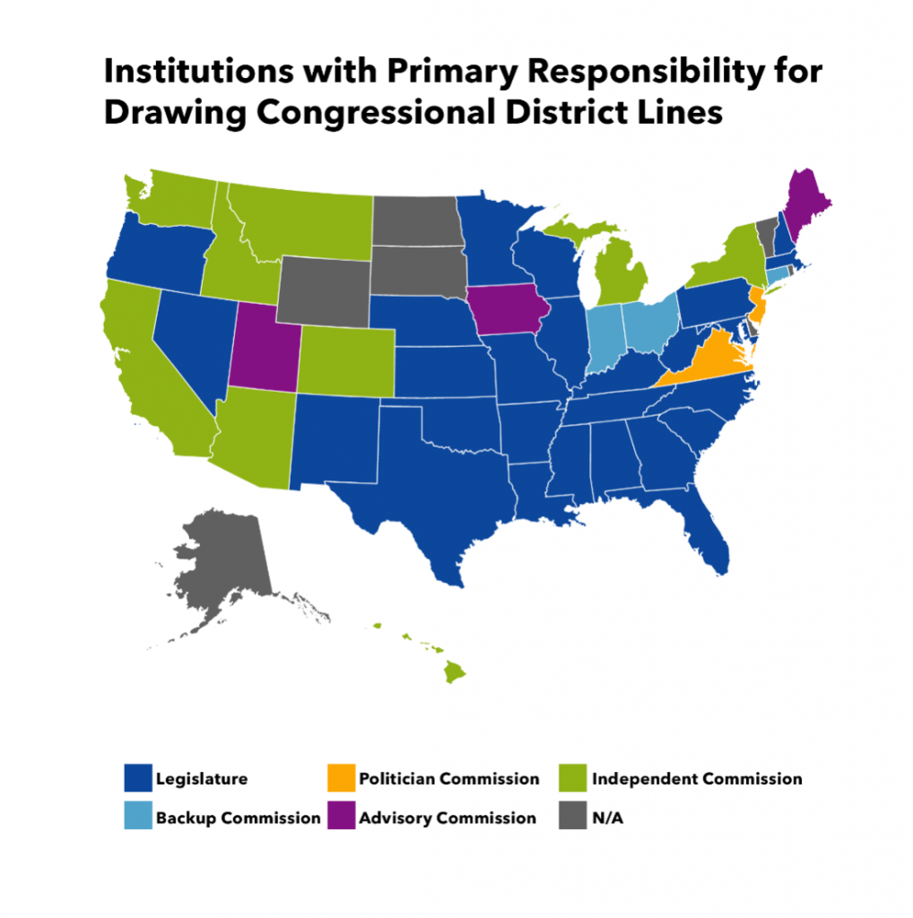
Most U.S. States give primary control of congressional redistricting to state legislatures. In 39 states, the legislature control congressional redistricting (that includes seven states with populations so small that they have a single seat in the U.S. House of Representatives). However, the exact nature of this legislative control varies significantly. In most cases, legislative redistricting plans are subject to gubernatorial veto like regular legislation. However, legislatures in five states—Connecticut, Florida, Maryland, Mississippi, and North Carolina—approve new congressional district lines via joint resolutions, thus removing the need for gubernatorial approval. Two states—Connecticut and Maine—require supermajorities in each legislative chamber to approve redistricting plans, while the legislatures in New York and Washington can override their independent commissions with a supermajority. Finally, Ohio gives a bipartisan supermajority in the legislature redistricting power first, though an independent commission takes over if the legislature fails to reach agreement.
Among states where legislatures draw congressional districts, four appoint advisory commissions and three use backup commissions to aid the redistricting process. Advisory commissions influence redistricting plans before they are considered by the legislature, while backup commissions contribute to redistricting plans after legislative review. In Iowa, Maine, Utah, and Vermont, advisory commissions are appointed to recommend congressional district lines. In three states—Connecticut, Indiana, and Ohio—backup commissions take over the state-level redistricting process if the legislature fails to pass a plan.
Several states task political commissions with drawing new congressional districts. The key difference between political and independent commissions is that elected officials can serve on political commissions. In three states—Hawaii, New Jersey, and Virginia—political commissions draw districts. The structure of these commissions varies by state. Virginia, for example, six legislators and six independent citizens are appointed to its commission.
Finally, nine states—Alaska, Arizona, California, Colorado, Idaho, Michigan, Montana, New York, and Washington—give independent commissions control over the congressional redistricting process. Members of these commissions cannot be legislators or elected officials, and state laws limit participation by public officials in the redistricting process. All these states except Colorado and New York ban commission members from running for office for several years in districts they draw. Legislative staff are barred from serving on these commissions in Arizona, California, Colorado, Michigan, and New York, while lobbyists cannot serve in California, Colorado, Idaho, Michigan, New York, and Washington. Finally, state legislatures in New York and Washington can override their commissions with a supermajority.
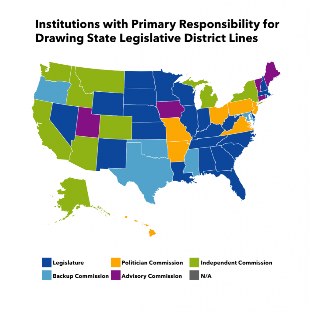
As with congressional redistricting, most U.S. states gives primary control of the redistricting process for state legislative districts to the state legislatures. In 34 states, legislatures control over state-level redistricting occurs, though how state legislative district lines are drawn differs from congressional redistricting.
| Redistricting Control | State Legislative Redistricting | Congressional Redistricting |
| State Legislatures | 22 States | 26 States |
| Advisory Commissions | 4 States | 3 States |
| Backup Commissions | 8 States | 3 States |
| Political Commissions | 7 States | 3 States |
| Independent Commissions | 9 States | 8 States |
| Single District States | N/A | 7 States |
Congressional Redistricting Rules & Criteria
In addition to who leads the congressional redistricting process, state and federal authorities set legal requirements and guidelines to reduce partisan redistricting and protect racial minorities, ethnic groups, and other communities of interest. Article 1, Section 2 of the U.S. Constitution mandates: “Representatives and direct Taxes shall be apportioned among the several States which may be included within this Union, according to their respective Numbers.” The U.S. Supreme Court has read this to mean that congressional districts must contain approximately the same number of people. In addition to the U.S. Constitution, 14 states apply the same principle to congressional districts.
The next most important rules governing the redistricting process address minority representation. In the past, political actors disenfranchised minority populations through cracking (splitting members of a minority group across several districts and, thus, diluting its political power) and packing (pushing as many minority voters as possible into a few concentrated districts, therefore draining that group’s political power from the rest of the state). The Federal Voting Rights Act of 1965 prohibited district lines that disempower minority populations, although the Supreme Court has since severely weakened federal enforcement of these rules.
One result of the Voting Rights Act is the presence of majority-minority congressional districts (i.e. districts where non-Whites constitute a majority of voters)in 26 states. There were 122 majority-minority districts nationwide in 2015, and 16% of each state’s congressional districts were majority-minority, on average. Outside of federal law, only four states apply the same criteria to congressional redistricting.
Another near-universal rule for the redistricting process is contiguity. An electoral district is contiguous if one can travel from any point in the district to any other point without having to cross its boundary. Some exceptions to the contiguity rule are permitted by federal courts if a reasonable context exists, such as separation by rivers, lakes, or seas. Besides federal legal requirements, 18 states require contiguity for congressional districts.
States often require district lines to follow underlying political boundaries like county, city, town, or ward lines. In 2012, for example, the Supreme Court approved a West Virginia redistricting plan that slightly violated the ‘equal population’ rule because it allowed congressional districts to follow county lines. In 15 states, there is a requirement that congressional districts follow existing political boundaries at least somewhat.
Another common redistricting requirement is compactness, a term which lacks a universal political definition but is often determined by a district’s geometric shape. In 17 states, there is a requirement that congressional districts be compact. The three most common measures of compactness are less contorted—or ‘smoother’— boundaries, less dispersion—or districts with less spread from their central core—and housing patterns. In practice, district compactness often is in the eye of the beholder: Arizona and Colorado focus on contorted boundaries; California, Michigan, Missouri, and Montana emphasize dispersion, and Idaho informs its commission to avoid “oddly shaped” districts. Only seven states appear to identify a specific measure of compactness.
States often emphasize preserving communities of interest as a redistricting criteria. These are a group of people with a common interest, be it economic, social, or otherwise. In 11 states, consideration is given to keeping communities of interest undivided when drawing new congressional districts.
Finally, some states restrict redistricting with the intent of producing partisan outcomes. Partisan redistricting occurs when electoral districts are drawn to favor or disfavor candidates of a certain party, or when districts substantially favor incumbent politicians over challengers. Efforts to restrict partisan redistricting have not fared well in federal courts. The Supreme Court explicitly allows the drawing of district lines to intentionally benefit incumbent politicians as well as redistricting to slightly advantage some partisan outcomes over others. Although the Supreme Court unanimously ruled that excessive partisanship in the redistricting process is illegal, it also has ruled that federal courts cannot consider claims of undue partisanship because they cannot develop a rule to determine when partisanship is excessive. Therefore, only state laws against partisan redistricting are enforced in the U.S. at present. The constitutions or statutes of 17 states prohibit partisan redistricting for congressional districts.
Some states apply these same rules and criteria to state legislative redistricting, while others exclusively apply them to state legislative districts. In fact, a far greater number of states set legal requirements on state-level redistricting that do not apply to congressional redistricting, which may suggest a politicization of the congressional redistricting process that is not present in the state legislative redistricting process. In 35 states, for example, laws require equal population across state legislative districts but only 14 states do the same for congressional redistricting. Similarly, nine states require that racial and ethnic minorities be considered in the state legislative redistricting process, but only four states apply the same criteria to congressional redistricting. The same pattern plays out for each other common redistricting rules and criteria:
| Redistricting Criteria | State Legislative Redistricting | Congressional Redistricting |
| Equal Population | 35 States | 14 States |
| Racial/Ethnic Minorities | 9 States | 4 States |
| Contiguity | 45 States | 18 States |
| Political Boundaries | 34 States | 15 States |
| Compactness | 32 States | 17 States |
| Communities of Interest | 15 States | 11 States |
| Partisan Outcomes | 19 States | 17 States |