
Following natural disasters and in times of national crisis, America’s private sector steps up to aid the states. We are proud of the herculean efforts of CSG Leadership Circle and Associates, our private sector members, as we combat COVID-19 together.
Associates in Action articles highlight CSG Associates’ philanthropic efforts and public-private partnerships throughout the states.
Esri, a CSG Leadership Circle member, developed a mapping resource to assist states battling the COVID-19 pandemic. As the health crisis evolved this spring, Esri supported users and the community-at-large with location intelligence and geographic information system (GIS) as well as mapping software, services and materials, which are helping state and local governments monitor, manage and communicate the impact of the outbreak. Esri also developed a COVID-19 resource portal containing software, templates for maps and informational products, and support materials including white papers, technical blogs and training content.
Additionally, the Esri COVID-19 GIS Hub contains valuable and ready-to-use demographic and other data from authoritative sources, the user community and business partners. It includes useful apps that immediately aid better understanding and decision-making. This website also offers a collection of datasets, applications and other helpful content for planning and response. These materials are updated with new content as it becomes available.
To help public health agencies and other organizations respond to COVID-19, Esri provided its ArcGIS Hub Coronavirus Response template, at no cost, through a complimentary six-month subscription of ArcGIS Online with ArcGIS Hub Basic. ArcGIS Hub is a framework to build a personalized website to visualize and analyze the crisis in the context of an organization’s or community’s population and assets. The template includes examples, materials and configurations to deploy the ArcGIS Hub environment rapidly.
Many states have already started to capitalize on their authoritative data with ArcGIS software. They can do this with software already licensed to rapidly implement solutions at no additional cost using ArcGIS Hub. This community engagement hub allows organizations to present one authoritative source for data, rapidly enable all departments with applications and tools, improve feedback mechanisms and enhance collaboration between departments and citizens.
While many parents are now juggling remote work and their children’s remote learning, on top of adjusting to the daily realities of quarantine during the COVID-19 pandemic, a significant number of essential workers must still report to work each day. These workersoften struggle to find childcare. In Washington, one of the states hardest hit by COVID-19, the governor’s office mandated that schools provide childcare for essential workers. However, not every school is participating, so it is difficult for parents to find which facilities are open. Staff at the state’s Washington Technology Solutions’ Office of the Chief Information Officer (OCIO) saw this disconnect and wanted to help.
Joanne Markert, geographic information systems coordinator for the OCIO and the geospatial team created an online, map-based dashboard to show which facilities are open for childcare. Essential workers can use the interactive dashboard to select a school district and quickly see available facilities. They can also click on the individual facility to learn more details such as the name, address, email and/or phone contact information, county location and hours.
Building the interactive map took collaboration across agencies and the use of geographic information system (GIS) technology from Esri. The team at OCIO used ArcGIS Dashboards from Esri to create the interactive map. Staff at the Office of the Superintendent of Public Instruction provided the underlying GIS data on schools and school districts. The State Emergency Operations Center provided additional information about hours of operation, specific email addresses or phone numbers to contact, and alternative sites such as Boys & Girls Clubs of America working in partnership with the schools.
The public can access the dashboard on the Washington Geospatial Open Data Portal at geo.wa.gov. As with everything during these unpredictable times, the facilities and their availability are constantly changing, so the dashboard provides workers one authoritative place for the most current status updates.
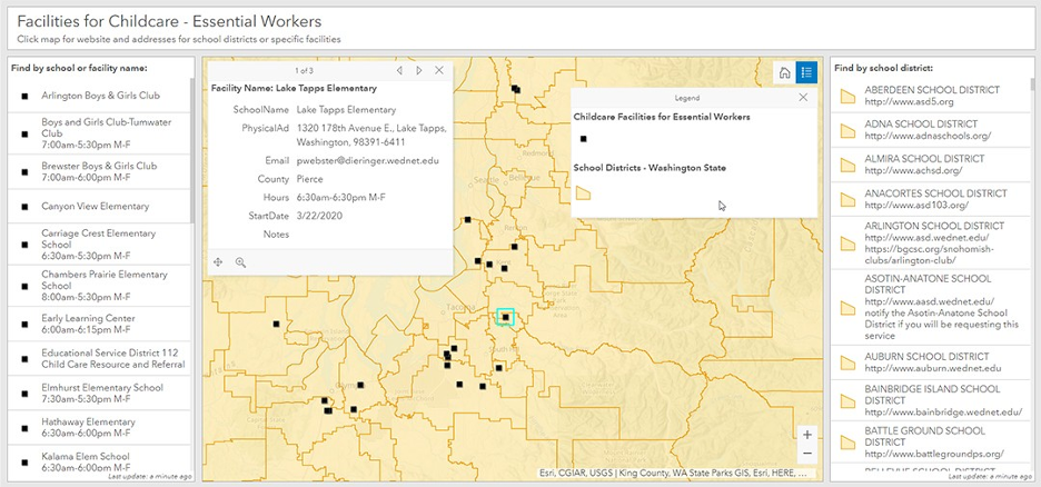
(The Washington state public dashboard uses GIS to enable essential workers to find the childcare facilities they need as of April 2020.)
In addition, Esri’s Disaster Response Program makes resources available at no cost that can help organizations prepare, manage and deliver an effective response to COVID‑19.
Esri can also help with data, software, configuration and technical support for user’s applications. If an organization’s GIS capacity has exceeded and is in need of emergency support, there are several ways Esri may be able to help. Esri is providing free GIS technology and on-call technical experts. For more than 25 years, Esri has supported communities and states with active emergency response and relief efforts.
“We have decades of experience helping communities respond to natural disasters and emergencies,” said Esri State Government Industry Solutions Manager Richard Leadbeater. “From tracking Ebola, West Nile and SARS, to 9/11, hurricane and wildfires response, Esri was there. While COVID-19 is different than anything we’ve ever seen before, as leaders of the GIS community, we are seeing this community come together to provide authoritative data, tools and lessons learned that help governments better understand the pandemic, protect our at-risk populations and prepare our communities for their inevitable economic recovery.”
For more information, visit: www.esri.com/en-us/covid-19